


Map, British, SAINT-AUBIN-SUR-MER, Juno Beach & Sword Beach, Normandy, 1943
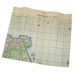
Rare genuine WWII British map, St. Aubin, Edition of Jul. 1943, Sheet No. 40/18 S.W., scale 1:25,000.
The present map covers a section of the Normandy coastline located between the villages of Saint-Aubin-sur-Mer in the west and La Brèche in the east, which includes Langrune-sur-Mer, Luc-sur-Mer and Lion-sur-Mer. The towns of Tailleville and Douvres-la-Délivrande, situated a bit further inland, are also visible.
This perimeter encompasses the eastern end of the Canadian sector, known as Juno Beach, where the North Shore (New Brunswick) landed in the first wave on D-Day, and the major part of Sword Beach, where various units attached to the 3rd British Infantry Division hit the shore along with Royal Marine Commandos.
Edited by the General Staff-Geographical Section of the War Office.
Very good overall condition. Dimensions: 19.6in x 24.4in.
Product Details
You might also like
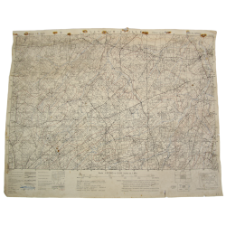
Rare genuine WWII British map, St. Aubin, Edition of Jul. 1943, Sheet No. 40/18 S.W., scale 1:25,000.
The present map covers a section of the Normandy coastline located between the villages of Saint-Aubin-sur-Mer in the west and La Brèche in the east, which includes Langrune-sur-Mer, Luc-sur-Mer and Lion-sur-Mer. The towns of Tailleville and Douvres-la-Délivrande, situated a bit further inland, are also visible.
This perimeter encompasses the eastern end of the Canadian sector, known as Juno Beach, where the North Shore (New Brunswick) landed in the first wave on D-Day, and the major part of Sword Beach, where various units attached to the 3rd British Infantry Division hit the shore along with Royal Marine Commandos.
Edited by the General Staff-Geographical Section of the War Office.
Very good overall condition. Dimensions: 19.6in x 24.4in.