High quality products
Unparalleled customer service
- Home
-
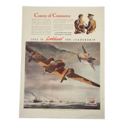
Original
- US ARMY
- British-Made
- Camp
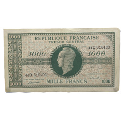
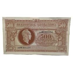
- Documents, maps & photographs
- Dog Tags
- Field Equipment
- Footwear
- Gas protection
- Goggles & Glasses
- Headgear
- Hygiene
- Optical & Compass
- Personal Items
- Rations & Tobacco
- Religious Artifacts
- Signal Corps
- Sports and recreation
- Survival
- Tanker
- Uniforms
- Vehicles
- Weapons
- THEMATICS US
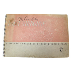
- AIRBORNE
- DEMOLITION
- FEMALE PERSONNEL
- FLAGS
- INSIGNIA AND DECORATIONS
- KNIVES
- M1 HELMET
- MEDICAL
- MILITARY POLICE
- MOUNTAIN TROOPS & FSSF
- SWEETHEART
- US NAVY
- USAAF
- USMC
- OTHER ERA
- Korea & Vietnam
- Modern wars
- World War I
-
Reproduction
- American
- Accessories
- Field equipment
- Footwear
- Headgear
- Hygiene
- Insignias & Decorations
- Awards
- Insignias
- Ranks
- Sleeve Insignias
- Personal items
- Rations & Tobacco
- Uniforms
- Weapons
- Thematics
- Airborne
- Female personnel
- Medical
- Other nationalities
- British & Commonwealth
- French
- German
- Paint
- Paint, spray, 400 ml
- Paint, 1 kg
- Identity tags
- Dog Tags
- Books
- US TACTICAL
-
Souvenirs
- Clothing
- Polo shirts
- Sweatshirts
- Tee-shirts
- Jackets
- Miscellaneous
- Caps
- Caps
- Accessories
- Hats, beanies
- Sunglasses
- Belts
- Umbrellas
- Bags and purses
- Flags
- Stationery store
- Notebooks
- Pens, pencils
- Desk accessories
- Tableware
- Cookie tins
- Place mats
- Mugs
- Thermos
- Shot glasses
- Collectables
- Coins, medals, insignia
- Pin's
- Magnets
- Statues, figurines
- Zippos, lighters
- Key Rings
- Thimbles
- Postcards
- Snow globes
- Models
- Flasks
- Cutlery
- Licence plates
- Stickers
- Tin signs
- Christmas ornaments
- Miscellaneous
- DVD / Blu-ray
- 101st airborne shop
- D-Day Experience's official shop
- Identity tags
- D-Day Anniversary
- Poppies
- Kids
- Stuffed animals
- Toys
- Clothing
- Local products
- Local products
- D-DAY Experience
- Contact


 Paypal - 4x without fees
- Home
-
Original
- US ARMY
- British-Made
- Camp
- Documents, maps & photographs
- Dog Tags
- Field Equipment
- Footwear
- Gas protection
- Goggles & Glasses
- Headgear
- Hygiene
- Optical & Compass
- Personal Items
- Rations & Tobacco
- Religious Artifacts
- Signal Corps
- Sports and recreation
- Survival
- Tanker
- Uniforms
- Vehicles
- Weapons
- THEMATICS US
- AIRBORNE
- DEMOLITION
- FEMALE PERSONNEL
- FLAGS
- INSIGNIA AND DECORATIONS
- KNIVES
- M1 HELMET
- MEDICAL
- MILITARY POLICE
- MOUNTAIN TROOPS & FSSF
- SWEETHEART
- US NAVY
- USAAF
- USMC
- OTHER ERA
- Korea & Vietnam
- Modern wars
- World War I
-
Reproduction
- American
- Accessories
- Field equipment
- Footwear
- Headgear
- Hygiene
- Insignias & Decorations
- Awards
- Insignias
- Ranks
- Sleeve Insignias
- Personal items
- Rations & Tobacco
- Uniforms
- Weapons
- Thematics
- Airborne
- Female personnel
- Medical
- Other nationalities
- British & Commonwealth
- French
- German
- Paint
- Paint, spray, 400 ml
- Paint, 1 kg
- Identity tags
- Dog Tags
- Books
- US TACTICAL
-
Souvenirs
- Clothing
- Polo shirts
- Sweatshirts
- Tee-shirts
- Jackets
- Miscellaneous
- Caps
- Caps
- Accessories
- Hats, beanies
- Sunglasses
- Belts
- Umbrellas
- Bags and purses
- Flags
- Stationery store
- Notebooks
- Pens, pencils
- Desk accessories
- Tableware
- Cookie tins
- Place mats
- Mugs
- Thermos
- Shot glasses
- Collectables
- Coins, medals, insignia
- Pin's
- Magnets
- Statues, figurines
- Zippos, lighters
- Key Rings
- Thimbles
- Postcards
- Snow globes
- Models
- Flasks
- Cutlery
- Licence plates
- Stickers
- Tin signs
- Christmas ornaments
- Miscellaneous
- DVD / Blu-ray
- 101st airborne shop
- D-Day Experience's official shop
- Identity tags
- D-Day Anniversary
- Poppies
- Kids
- Stuffed animals
- Toys
- Clothing
- Local products
- Local products
- D-DAY Experience
- Contact