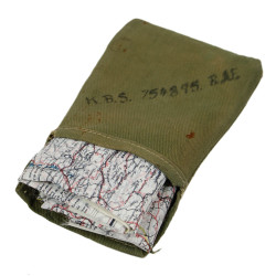


Maps, Silk, Escape, C/D & E/F, 1943, with Pouch, MAPS ONLY
Rare lot of two genuine WWII Allied double-sided silk escape map, heat-treated to prevent the cloth from unravelling.
This type was particularly issued to RAF and USAAF aircrews flying over German-occupied Europe as part of their escape and evasion kits.
Scale: 1:1,000,000. Dated 1943.
Map C/D: the first side covers the Netherlands, the largest part of Belgium, Luxembourg, north-eastern France and western Germany; the second side covers south-eastern France, south-western Germany, most of Switzerland and part of north-western Italy, and also offers an enlargement of the border region between Belgium, the Netherlands and Germany (scale: 1:250,000).
Map E/F: the first side covers northern Germany, the protectorate of Bohemia and Moravia, Slovakia, Poland and northern Hungary; the second side covers western and central Croatia, western Montenegro, western Hungary, southern Slovakia, southern Germany, northern and central Italy, as well as eastern Switzerland.
Great homogeneous set, in excellent overall condition, coming in its original rubberized cloth pouch (fragile).