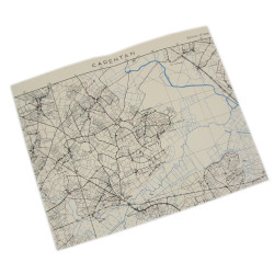
Rare genuine WWII Allied map La Haye du Puits, Sheet 6E/5, scale 1:50,000.
Third edition of 1943.
Drawn by the British Geographical Section-General Staff and initially published in 1942, the present map covers a large perimeter of the Cotentin Peninsula, including the tows of Saint-Sauveur-le-Vicomte, Sainte-Mère-Église, La Haye-du-Puits and Carentan.
The area encompasses most of the Drop Zones of the 82nd and 101st Airborne Divisions, as well as Le Mont Castre (Hill 122), where the 90th Infantry Division met a fierce German resistance in early July 1944.
The historical artifacts for sale at PARATROOPER’s are intended for collectors, history enthusiasts, historians and museum curators. These items do not glorify or promote any of the political, ideological or racial opinions related to the global conflicts that bathed the 20th century in blood.
Besides, we remind you that Article R.645-1 of the French Penal Code establishes fines applicable to fifth class contraventions (except in the specific cases of a filming, show or exhibition which refer to historical events) for any individual who wears a uniform, insignia or symbol reminiscent of those worn by members of the various organizations declared criminal in application of Article 9 of the Charter of the International Military Tribunal annexed to the London Agreement of August 8, 1945 – SS, SD, Gestapo, Nazi leaders (the Führer, the Reichsleitung, the Gauleiters and their main collaborators, the Ortsgruppenleiter, the Zellenleiter and the Blockleiter), or reminiscent of those worn by any person found guilty, by a French or International Jurisdiction, of one or several crimes against humanity established by Articles 211-1 to 212-3 or mentioned in Law No. 64-1326 of December 26, 1964.
The Code provides additional penalties, including the confiscation of the items used or intended for committing the offence.