


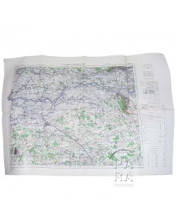
Map, German, SAINT-VAAST-LA-HOUGUE, Normandy, UTAH BEACH / 101st Airborne Sector
€95.00
Tax included
Genuine WWII German map of the Saint-Vaast-la-Hougue area, scale 1:25 000. Dated 1944, the present map covers a sector bounded by Saint-Pierre-Eglise, Barfleur, Theurthéville-Bocage and Tatihou. This area, north of Utah Beach, is also known as 'the sector of the lost paratroopers', referring to some troops of the 377th PFAB, 101st Airborne who were misdropped on June 6, 1944 in the vicinity of Quettehou, Réville, etc.
Deutsche Heereskarte - Nr. XIII-10/1-2-3 St. Vaast-la-Hougue Nr. 1-2-3.
Excellent overall condition. No tear/scratch/hole/annotation. Dimensions: 23.5in x 31.5in.
Product Details
Customers who bought this product also bought:
Please enter at least one character for your customization
Your customization has been saved