



Map, British, 'S HERTOGENBOSCH, 1943, Market Garden
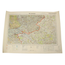
Genuine WWII British map, 'S Hertogenbosch, Third Edition, Sheet 5, scale 1:100,000.
Edited by the General Staff-Geographical Section of the War Office in 1913, second edition in 1943.
This map covers a large perimeter of southwestern Netherlands, including the agglomerations of Arnhem and Nijmegen, respectively assigned to the 1st British Airborne Division and the 82nd US Airborne Division on the occasion of Operation Market Garden in September 1944, as well as the northernmost part of the sector assigned to the 101st US Airborne Division.
Good overall condition.
Dimensions: about 27.15in x 38.55in.
Product Details
Wa0326